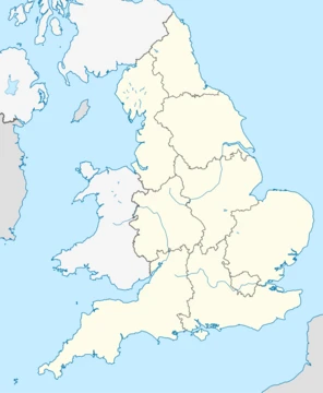
Dorset
Ceremonial county in South West England with Jurassic Coast.

Dorset is a ceremonial county in South West England, bordered by Somerset, Wiltshire, Hampshire, the English Channel, and Devon. Its largest settlement is Bournemouth, and it has a varied landscape of chalk downs, limestone ridges, and clay valleys, with much of its coastline forming part of the Jurassic Coast World Heritage Site.
- largest_settlement
- Bournemouth
Lore & Background
Dorset derives its name from the Dornsæte people, who inhabited the area during the Saxon period. The Saxons called the region Dornwaraceaster, and the inhabitants became known as Dornsæte. The county's archaic name Dorseteschyre was first recorded in the 10th century. The Romans arrived in AD 43, capturing Maiden Castle under Vespasian. Post-Roman inhabitants built Bokerley Dyke to delay Saxon advance, but by the end of the 7th century Dorset was under Saxon control and incorporated into the Kingdom of Wessex. Following the Norman Conquest, castles were built at Corfe, Wareham, and Dorchester. During the Second World War, Dorset was heavily involved in preparations for the invasion of Normandy.
Reader's Guide
Dorset's significance lies in its rich geological and historical heritage. The Jurassic Coast World Heritage Site, covering most of its coastline, is internationally important for its geological and palaeontological features, including Lulworth Cove, the Isle of Portland, Chesil Beach, and Durdle Door. The county was a focal point for civil unrest: the Clubmen uprising during the English Civil War, the Monmouth Rebellion beginning at Lyme Regis, and the Tolpuddle Martyrs' case, which helped spark the trade union movement. Agriculture was historically the major industry, but has declined in favour of tourism. The county's landscape of chalk downs, limestone ridges, and clay valleys, along with its prehistoric monuments like Maiden Castle and the Dorset Cursus, reflect continuous human occupation from the Mesolithic period onward. Dorset's administrative structure now comprises two unitary authority areas: Bournemouth, Christchurch and Poole, and the rest of Dorset.
Did You Know?
- The Tolpuddle Martyrs, six Dorset farm labourers, were instrumental in the formation of the trade union movement.
Ancient Roots and Shared Governance
Dorset's territorial identity stretches back to the earliest political divisions of the British Isles. Before the year 500, the area formed part of Dumnonia, a Brythonic kingdom occupying what is now the South West of England. Following the Roman withdrawal, the broader landscape was reorganised into seven Anglo-Saxon kingdoms, among them Wessex, a polity generally treated as interchangeable with the modern West Country, with the exception of Cornwall. This long period of shared authority means that the boundaries now taken for granted between Dorset and Somerset were, for generations, more a matter of convention than of practical administration.
The West Country and Wessex Identity
Dorset occupies a distinctive position within the web of informal and cultural regional labels that English people use to orient themselves geographically. The West Country is one of the most widely recognised of these designations, and it is often treated as essentially synonymous with Wessex, the name of the ancient Anglo-Saxon kingdom, with the sole caveat that Cornwall is typically excluded from the Wessex label. Dorset sits comfortably within both of these overlapping spheres, meaning that in everyday conversation a resident might describe their home as being in the West Country, in Wessex, or simply in Southern England, all of which are valid and widely used informal designations. The Heptarchy framework, which preserved the names of former kingdoms that never became modern counties, continues to be invoked by organisations when defining regions, and Wessex remains the relevant entry for much of Dorset's territory. This layered nomenclature reflects a broader pattern in England, where dozens of alternative regional names—ranging from the Black Country to the Cinque Ports, from the Cotswolds to the Weald—coexist alongside official administrative boundaries, giving places like Dorset multiple cultural addresses simultaneously.
Economic Planning and Statistical Grouping
This arrangement reflected a pragmatic approach to regional policy, bundling counties with shared geographic and economic characteristics into a single planning unit. The same South West configuration carried forward into the standard statistical regions that preceded the government office regions, ensuring continuity in how data about Dorset was collected and reported. Before the Government Office Regions were created in 1994 and subsequently adopted for statistical purposes in 1999, these eight standard statistical regions served as the primary framework for national data, and Dorset's inclusion in the South West was a constant feature.
Institutional and Cultural Frameworks
In the present day, Dorset's place within England's institutional map is shaped by several overlapping frameworks. The National Trust maintains ten regional offices across England, and Dorset falls under the Wessex office, which covers South West England minus Devon and Cornwall. This is a subtly different boundary from the official South West government region, which does include Devon and Cornwall, illustrating how institutional choices about regional grouping can shift a county's perceived identity. Britain in Bloom, a national gardening and horticultural campaign, divides England into twelve regions that blend government boundaries with altered names; Dorset would sit within the South-and-South-West grouping that encompasses part of the south east and south west. Postcode areas also serve as informal geographic markers for statistics, though no specific postcode area is named for Dorset in the available records. Together, these varied schemes—governmental, charitable, and cultural—mean that Dorset's regional affiliation is never a single fixed point but rather a matter of which institutional lens one applies.
Frequently Asked Questions
What makes Dorset's coastline so famous?
A large stretch of its shoreline forms part of the Jurassic Coast, a UNESCO World Heritage Site celebrated for its exposed geological strata. Beyond the coast, the county's interior is a patchwork of chalk downs, limestone ridges, and clay valleys.
More in Regions Of England 1-18
Spotted an error? Know more?
This is a living reference — every entry is fact-audited, and reader corrections feed straight into our audit queue. Suggest an edit · See this site's audit record